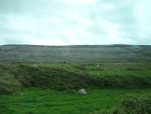
 view of the Burren from the bus
 Yesterday, on our way to the Cliffs of Moher, our bus passed through this strange landscape, known as The Burren. It's unique appearance is due to the fact that the ground is mostly covered in limestone blocks, with plants growing from the cracks in between. This makes the whole place look almost like a sort of lunar landscape, with large grey rocks covering the majority of the land, and stray plants growing between them. Despite it's inhospitable appearance, the Burren is actually the site of lots of plant and animal life. A portion of the land has been made into a protected park area, called Burren National Park, which stretches out over 15 square kilometers. The entirety of the Burren is 250 square kilometers, and much of it is used as farmland. Because it is such a unique ecosystem, nearly all of the Burren is designated a Special Area of Conservation, and the farmers who live here use very sustainable methods to ensure the preservation of this place.
This site is very well known for two things: its biodiversity and its archaeological sites.
This site is very well known for two things: its biodiversity and its archaeological sites.
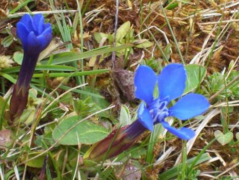 the Gentian flower, photo from the national park site
 The Burren gets its name from the Irish word "Boireann," meaning a rocky place, though in the past, it has more often been called the "fertile rock," a very valid nickname. Of all the native types of plants and trees that grow in Ireland, 70% - 75% can be found here, including plants that rang from alpine to Mediterranean, from thistles to orchids. These many different plants grow in the cracks between the limestone rock, fertilized by the deposits of sediment that have been built up since the carboniferous period, and kept frost-free by the gulf stream winds. When it comes to animals, the burren houses dozens of types of mammals, birds, invertebrates, reptiles, amphibians, and fish. This land is also farmland, which means it is not uncommon to see farmers' cows, goats, and sheep grazing here. The area is well known for the farmer's dedication to keeping the ecosystem intact. The grazing of animals is restricted to certain areas during certain times, ensuring that the plants are never decimated by the livestock. Farmers will have their cattle graze in the most plant-dense areas in the winter (when they eat the more), and then move them back towards the south for the summer. This not only ensure that no one area is completely killed off, but creates room for the new spring plants that would otherwise struggle to grow in the dense areas. This amount of cooperation between the farmers and the ecosystem, and the constant dedication to keep the Burren a stable place is very interesting, and a real ecological success story.
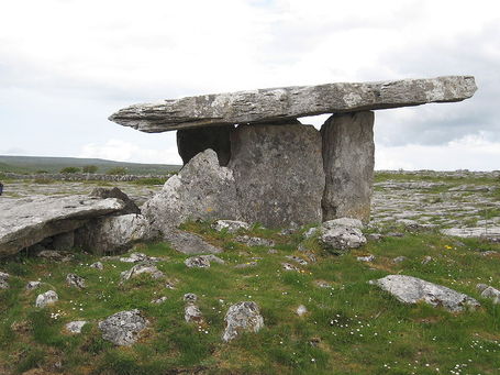 megalithic portal tomb (aka portal dolmen), photo from wikipedia
 As with much of Ireland, the Burren is rich in archaeological sites. I spoke about some of the ancient architecture in yesterday's post, and this site is home to hundreds of structures. There have been sites excavated here that date from the Mesolithic to the Iron Age, with the most famous (including ring forts) structures having been built in the Neolithic. These are mainly tombs, showing evidence of farming civilizations in the area. The most famous site (seen in the picture to the right) is the Portal Tomb, or Portal Dolmen at Poulnabrone. This dolmen has been dated back to c. 3600 BC. It faces north-east, and has a 12ft by 7ft capstone. The area was excavated, and the remains of 16 to 22 adults were found there, along with the bones of 6 juveniles, which were buried over the course of six centuries. Most of the people buried here died before they were 30, mostly from high levels of stress and overexertion. Like most prehistoric people, the early inhabitants of the Burren essentially worked themselves to death. Even beyond the Portal Dolmen however, many, many tombs have been found, including one site with such a high density that some archaeologists suggest it may have been a megalithic cemetery.
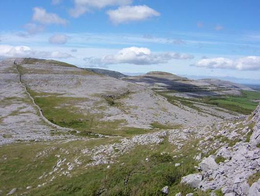 view of the Burren, photo from the national park site
 Researching the Burren made me even more curious about the different landscapes of Ireland. I would love to go visit the Burren one day, and see more of this unique landscape.

 RSS Feed